
“For Wilderness Travelers, good navigation ability can mean the difference between a successful day hike and an unplanned Overnight Stay”
– Darren Wells, NOLS Wilderness Navigation
If a carpenter arrived at your Home to do renovations with only a hammer in his tool belt you would be scared that you had hired an amateur, because real carpenters have many tools in their tool belts. It is interesting that so many “expert wilderness navigators” wander into the wilderness with either no tools or only one tool in their navigator’s tool belt. It is also said that some will even carry navigation tools into the wilderness without the ability to use them. That’s like a carpenter carrying a tape measure that they hardly understand how to use.
“By failing to prepare, you are preparing to fail” – Benjamin Franklin
I am a firm believer that the more tools you carry with you and understand how to use, the better prepared you will be as a wilderness navigator. The three principal or critical tools are the Magnetic Compass, a Large Scale Topographical Map, and a GPS Receiver. The other additional navigation tools are all useful in many circumstances as you plan and travel your routes.
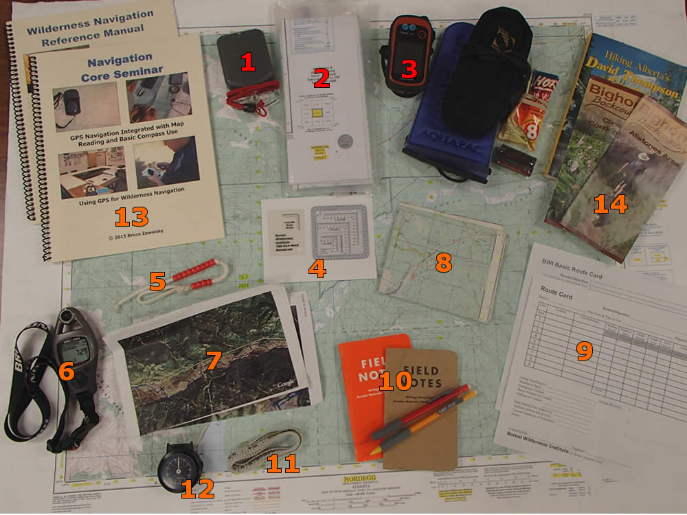
Critical Navigation Tools
- Magnetic Compass: Best Available is a genuine Silva Expedition 15TDCL 360. You will need to order one from Britain or Ireland as they are sadly not sold in North America. See Magnetic Compass Use Hints for more details and options.
- Large Scale Topographical Map: 1:50,000 Scale. Every map should have its Grid References and other critical navigation information highlighted with a bright yellow highlighter and waterproofed by placing it in a sealable plastic bag, map case, or using a liquid waterproofer on the map itself. These maps can be backed up with but not replaced by GPS topographical maps of the area uploaded into your GPS or smartphone.
- GPS Receiver: nice choice today for a handheld GPS is a Garmin eTrex 20. It is fairly inexpensive, can accept a large Micro SD Card for carrying topographical maps, and has a readable colour screen. GPS Accessories to keep it working include Spare Batteries, Handwarmer with an elastic band to keep it going in cold weather, Soft Case if you are travelling on land, or a Waterproof Case with a tie to secure it to your watercraft if you travel on water and an interface cable. GSP Receiver as Part of the Navigators Toolbelt.
Addition Navigation Tools
- Romer: 1:50,000, Print Your Own Romer.
- Pace Beads: allow you to measure distance travelled on the ground. Build Pace Beads
- Altimeter: allows altimeter navigation & contouring. I use a Brunton ADC-Summit which is also a reasonably accurate field weather forecaster.
- Air Photos: of Critical/Complex Areas you will be travelling in. This can be backed up with Air Photos uploaded into your GPS or smartphone.
- Small Scale Topographical Map: 1:250,000 Scale. This can also be backed up with GPS Topographical Map of the Region in your GPS.
- Route Card: allows more organized preplanning of routes. It also speeds up the SAR process if you get lost and you give it to someone who will initiate your rescue plan when you don’t check-in. Always file out a route card before going into the wilderness, Print Your Own Route Card.
- Pencil & Notepad: the pencil allows proper map marking and a notepad means you can record Grids, make other notes as you travel or even leave a note for rescuers.
- Flexible Ruler: excellent for measuring distance and it also helps greatly if you need to read or plot Latitude & Longitude on a map accurately.
- Pedometer: can be used to measure distance travelled on the ground if you have a good steady pace and fairly even ground.
- Navigation Training: the more professional wilderness navigation training you take, the better prepared you will be and the fewer mistakes you will make when travel gets critical or weather worsens.
- Guide Books & Local Knowledge: Picking up a Guide Book, Trail Guide or Route Map for the specific route or even the area before you go into the wilderness is a great idea. Read them before you go. Supplement this with local knowledge before you go by searching the internet for information, or by asking locals when you arrive in the area and reading posted signage.
You need to learn to use each tool you carry in your tool belt and some of these tools will take more practice to learn to use than others. Remember the more tools you carry in your “Navigators Tool Belt” the better prepared you will be when you encounter problems in your wilderness travels.
Additional Resources
- Complete Wilderness Navigation [5-Days, Includes GPS Training]
- Navigation Core Seminar [7-Hours, Includes GPS Training]
- Why Proper Navigation Training is Necessary [Article]